
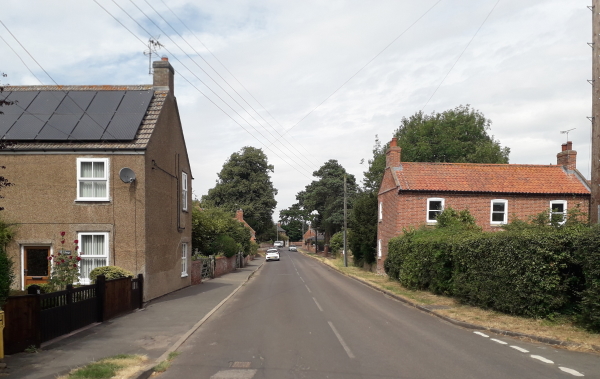
At the southern end of the High Street there is a three-way junction where Lincoln Road and Newark Road join on. We are now heading south down Newark Road…
The “Old Manor House”, c1920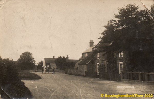
 This postally-used postcard – sent to a Miss (or Mrs) G. Wattam in Melton Mowbray – is probably from around 1920. It clearly shows the “Old Manor House” in the right foreground with the fence (now replaced by tall hedging) leading off down Hall Wath. This is the site of Edmund Thorald’s Manor House which was probably built for Benjamin Bromhead’s daughter, Jane, when she married in 1769*. There is a row of bricks jutting out half-way up the building which is a feature of several buildings in the village. The low building abutting the house, the farmhouse peeping out behind and the stone Rector’s house in the distance (behind the horse and cart) are all still standing today. The “Old Manor House” is number 2 Newark Road, and is yet another of the village’s Grade II listed buildings. More about its value can be read HERE.
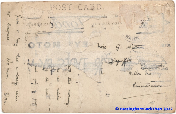 As you can see, the back of the card is very damaged and the postmark has been obliterated. There were Wattams in the village and a 1909 school football team photograph shows one of the young boys. The bits of text which are legible [together with my hypotheses!] read, “[Thank you for your] letter this morning… in return… of the week… and you a few lines. Jack and May had a lovely time at Skegness. No more. Dora” In the 1911 census Dora Wattam was aged 11 and her sister Gladys was one year older. They lived with their father, John Henry Wattam, a 52-years-old farm labourer from North Carlton and mother Ann (47) born in North Wheatley, Notts. Older brother George (26) was working as a general labourer whilst Rose (23) was unemployed and John (15) was an errand boy (was he the “Jack” of the postcard?) I would suggest that this is our family and the postcard was sent closer to 1920; that is not a child’s handwriting.
*The Bromheads were a military family from Thurlby Hall, several of whom are buried in St. Germain’s churchyard, Thurlby. Lieutenant Gonnville Bromhead was the character played by Michael Caine in the 1964 film “Zulu” although he died and is buried in Allahabad, India.
“Village Farmhouse” and the Church (c1910)
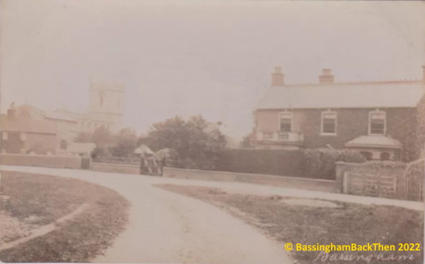
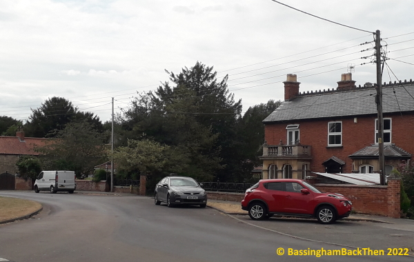
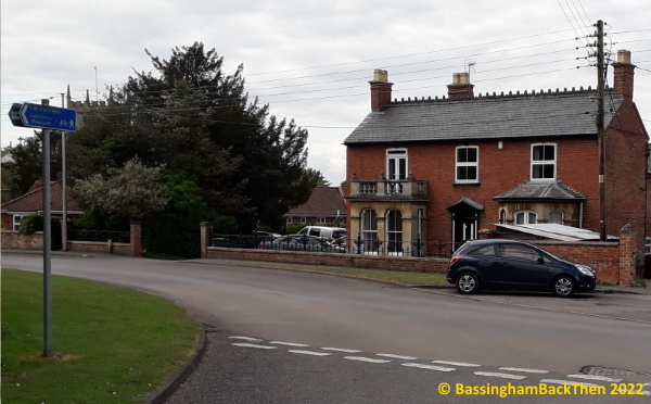 This undated postcard is taken at the junction of where Newark Road ends and the High Street begins. The building was originally a village farmhouse built around 1840 for a farmer/landowner. It’s possible that the balcony was added for guests to enjoy the annual gathering of the beagles for the hunt. The building now belongs to Scatliffe Motors, the local garage and is numbered 4 Newark Road. The frontage of the house remains pretty much as it looked over one hundred years ago, although the hedging of the garden has vanished. The church can also clearly be seen here although it is now almost totally obscured by the tree at left and the little ‘island’ of grass in the road has gone. Also visible at the extreme left is the stone house which was the home of the original Rector.
“The Green”, Newark Road (c1915)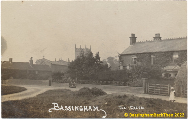
 This postcard is almost identical to the one above although I would date it a little later based upon the greater expanse of ivy on “Village Farmhouse”. Again, the Church is very obvious in the original postcard but is now obscured by greenery.
“Village Farmhouse” (Scatliffe Motors) (1908)
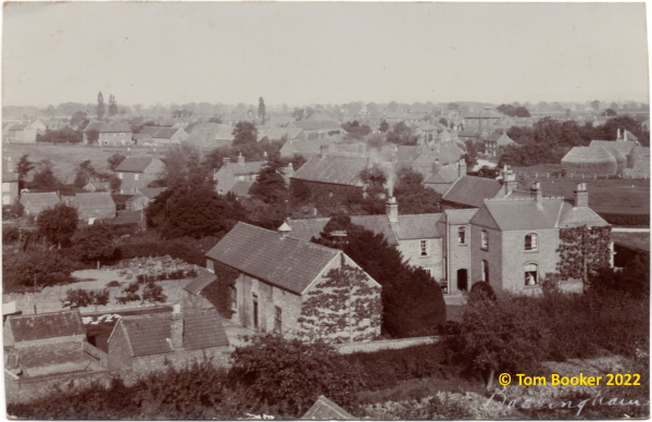
This is an astonishing postcard. I think that it is franked Dec 2 1908 (below) and was taken from the top of the church. The buildings in the foreground are clearly “Village Farmhouse” (what is now Scatliffe Motors) and, using that as a reference point, it is relatively easy to make out other buildings, especially the square Wesleyan Chapel to the north. You will, of course, appreciate that I am not going to be able to provide a comparable photograph nowadays!
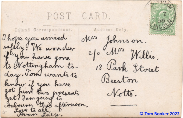
It is also yet another postcard written by [Edith] Lucy Johnson of “Ivy House”. I won’t transcribe the text for you here as it is easy enough to read. The “Tom” in question was her younger brother, Thomas (born 1900), Mrs Johnson was her mother, and Mr’s Willis was her maternal grandmother.
Newark Road, looking south (1912)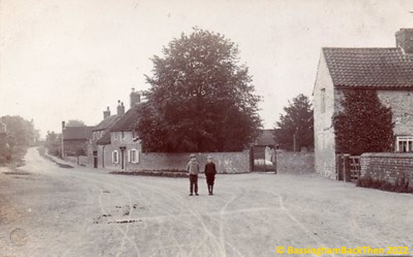
 The above postcard – dated 19th September 1912 – shows the view south down Newark Road as one approaches the church of St. Michael & All Angels. The building to the right is the only original stone-built cottage left in the village and was one of two owned by the Rector. It is another of the village’s Grade II listed buildings and during the 19th century it was the Farmer’s workshop for “Manor Farmhouse” on Whites Lane. The gate to the churchyard is still very recognisable although the tree in the churchyard has grown somewhat over time. The houses further down the road – including “Yew Tree Cottage” – are still there and seem to have changed very little.
The Old School (c.1910s)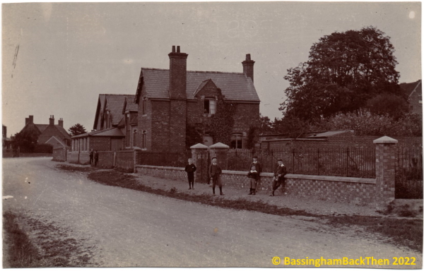
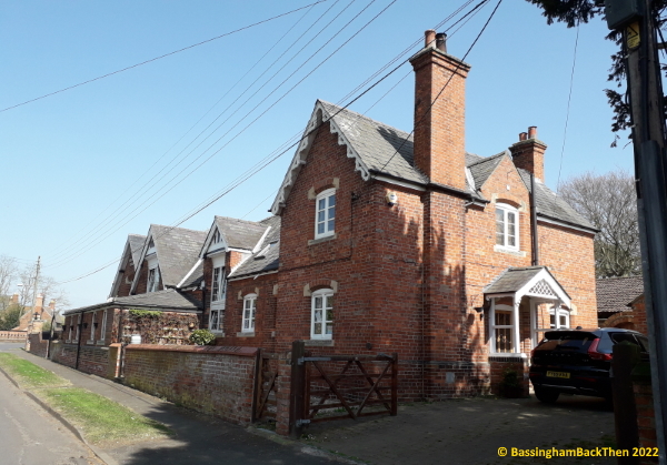 The National School was built in 1855 with a Church of England Foundation, the result of much fundraising in the village. It was forced to change to a Board School in 1893 and in 1902 control was handed over to the County Council. It finally closed its doors in 1982 after which it was used as a church hall for a few years before being sold into private hands in 1986. The boys are leaning against the wall and railing of the new ‘overspill’ graveyard (opened 1902 in land given by John Brocklebank in memory of his father). The low wall and railings are still there today although they appear nowhere near as tall as they were, the level of the road having been raised in recent years. The buildings themselves appear unchanged even down to the decoration on the frontage of the near end gable. Although conjoined, the building was – and still is – two separate entities: the longer school itself on the left and “The Master’s House” at the nearest end (with the two chimneys).
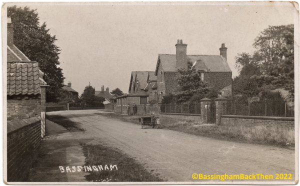 And another view, this time from a postcard stamped Newark, 25th August 1925 and sent by Gladys to her friend, Mrs Gregory, in Clapham. Ivy has almost completely covered the southern end of the building at this point, and the tree which makes comparative photographing so difficult these days is already well on its way to growing large. And that’s a motorbike and sidecar parked outside the overspill cemetery; beats arriving in a hearse any day! 😂😂
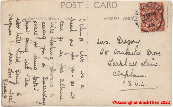 The message on the back of the postcard reflects a time when postcards were still a novelty and something to be collected, reading: “I think this is a fresh one for you – so it can go in your album. We’re looking forward to seeing you on Saturday shall you bring [???] Just going with tea hill field. Going to Skegness to-morrow. Love to both. Gladys.”
And here is a group photograph of the “Class of 1926”! The board is very difficult to read although I can confirm that it definitely says “1926 Bassingham C. [Council] School”. The children are lined-up in front of a wall of the school. My grateful thanks go to Derek & Caroline Rossin who lent me the original postcard to scan and present for you here.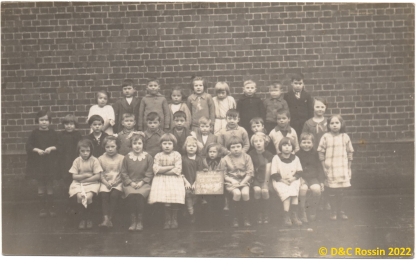
Newark Road, looking north (c1910)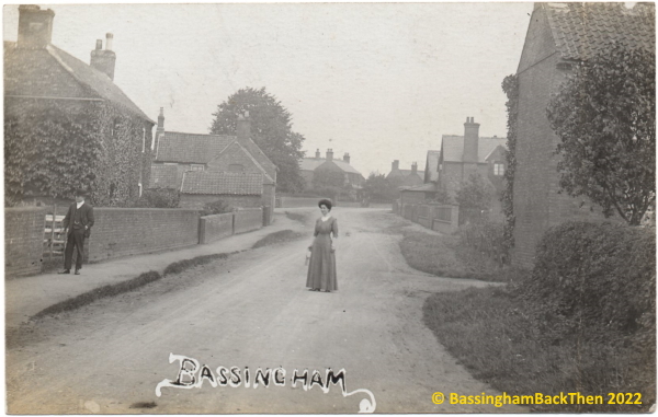
 Other than the spreading foliage which, as ever, makes comparison difficult, not an awful lot has changed from this undated – but probably around 1910 – postcard. The house on the right of shot – now with two windows in the wall – is “The Old Bakery”, 1 Bakers Lane (of course!); the Master’s House and School can be seen further up the road on the right. On the left we see 14 Newark Road, “Witham House” (home to the village’s first Post Office opened by Robert Pacey Boole) and, again in the distance, the window in the gable-end of “Yew Tree Cottage”, 10 Newark Road (there was yet another blacksmith’s forge here, the third in the village!) Right in the middle of the postcard is “Village Farmhouse”, now home to Scatliffe Motors.
 This lovely postcard is made all the more interesting by the two people on view. Who are they? Are they your ancestors? Common sense suggests that they might be residents of this part of Newark Road, although they could just as easily be ‘nobodies’ placed in shot to add some ‘life’. Anyway, please get in touch if you recognise either or both. 😉
Southern end, looking north (c1910)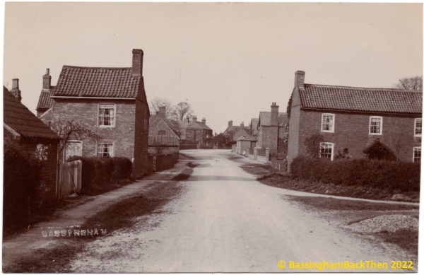
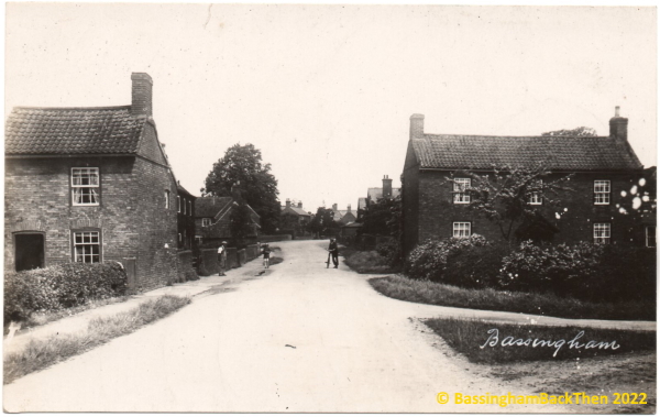
 Two undated postcards here are from roughly the same date, although I would guess that the first postcard is the older given the growth of trees and bushes in the second one (but I could, of course, be wrong). Using the previous 1912 view down Newark Road we can see that “The Cottage” (on the left) had already been extended by then so these two cannot possibly be later than that date. On the right we see “The Old Bakery” where, in 1851, John Harris the baker lived and thus the lane received its name. The low-roofed building near the camera in the first postcard is no longer there, and “The Cottage” has now acquired solar panels and a SKY dish and has, of course, doubled in size (a job done by the grandfather of current owner, Madeline Vickers).
Southern end, looking north (undated)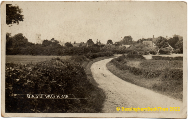 Now then… this one has me completely foxed at the moment. I simply cannot work out where this was taken from. Judging by the angle of the church, it has to be somewhere off to the southwest of Newark Road itself, very close to the riverbank, but I cannot find any track there nowadays. I think that I can definitely identify the Rectory/Care Home with its central gable and chimney stacks in the distance to the right of the end of the church, but at the moment I cannot identify any other buildings. The school was built in 1855 so it has to be there somewhere – obscured by trees possibly? We surely must be looking at the backs of the houses on Newark Road at the right of the photograph. Are they ‘Yew Tree Cottage’ and ‘Witham House’?
Here are a few close-ups to help identify the scene. I’m pretty certain that this is the old Rectory…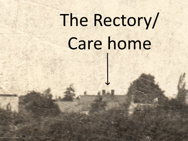 and the buildings to the right of the picture…
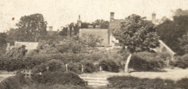 In terms of a date I’d say that this postcard is c1910-20. There are other postcards from the same publisher; the word BASSINGHAM in upper case and between two lines appears on two or three other examples spread across this site.
 BACK HOME
They’re great Roger. I was surprised to see some of the houses in the pictures as I thought they had been built a lot later, especially in Newark Road! 😃
LikeLike
Thanks for the comment, Blueeyes1954.
Yes, it is always quite an eye-opener as to just how old some of the properties are.
What a wonderful little village this is! 🙂
Roger
LikeLike
Could the last picture be of Rinks Lane (?). The road that goes to Scottwater Bridge and Norton Disney ?
LikeLike
I wondered about this too, James – thanks for your input.
Judging by the proximity of the church in the photograph I honestly don’t think that it’s that far down.
I have been down as far as the old Mill but still can’t get a satisfactory view.
The key is the tower of the church; we can clearly see the south face of it, but we can also see the west face too (at an angle), so I need to be standing somewhere to the southwest of the church.
Roger 👍
LikeLike
Is it surely not Rinks Lane with the bends of the road. If you zoom in on the right can you not see the flat roof of the Manor and its top row of windows above the house on the right?
LikeLike
Whilst I agree that it’s not as far as Rinks Lane, John, I can’t see the Manor House – and I have enlarged the original x8!
The Manor House would surely be much bigger as it would be closer to the camera?
Roger 👍
LikeLike
Simple fact is that there are only two roads going south from the village. Carlton Road, which this obviously is not, and Rinks Lane. Somewhere close to where this picture was taken there was a cart track which connected the two roads. It would have been to the right of this view. Is that still there ?
LikeLike
I take your point, James, but there is no way that this can be to the right (east) of Newark Road because of the visible angle of the church tower.
I’m convinced that it was taken in what is now a back garden – or an infill property – on Newark Road.
Has to be.
Roger 👍
LikeLike
I always thought it became Rinks Lane after the Manor House. Newark Road is a fairly new title. They are one and the same.
LikeLike