
Census records are currently held at the National Archives and can be viewed using various pay-per-view search engines such as Ancestry and FindMyPast. Bassingham, of course, features in all of them making it possible to trace individuals and families through the decades. For those of you who have access to Ancestry I have linked each of these records so that you can trace people from the village. Those of you without – if you ask me nicely, I might just do it for you! 😁
As you will discover, very few of any roads are named in any of the Census records. Exceptions tend to be High/Principal Street, Water Lane and Newark Road while smaller roads/streets such as Eastgate, Lincoln Road, Croft Lane, Linga Lane tend not to be named specifically. However, one road does crop up on more than one occasion, the mysterious “Back Street/Road”. I found the following information online:
In most villages and towns you will see a lane called ‘Back Lane’. This is showing us the medieval layout of the village. These ‘Back Lanes’ will be facing the high street. The modern shops and houses lining the High Street continue to sit on the same slender burgage plots, a layout that harks back almost 1000 years. To compensate for their limited street frontage, each plot extends deeply, featuring a lengthy strip of land at the rear. These plots were called a Burgage Plot.
These plots were characteristically long and narrow strips of land, extending back from a main street or market place. This design maximized the number of properties with street frontage, which was highly valuable for commercial activities in bustling urban centres.
The front part of a burgage plot, which directly faced the street, was typically utilised for business purposes, such as shops, workshops, or taverns. Behind these commercial fronts, the plot would often include living quarters, along with gardens for growing food and keeping animals for the table. Lanes were constructed to provide access from behind. Initially referred to as ‘back lanes”.
So here, I have outlined (this was done by me not a 5 year old) the Back Lanes of Cerne Abbas, Dorset, Ramsbury, Wiltshire and thanks to Adrian B, Debenham, Suffolk. You can see the Back Lanes running parallel with the High Streets. The Burgage Plots can just about be made out in the Cerne Abbas shot.
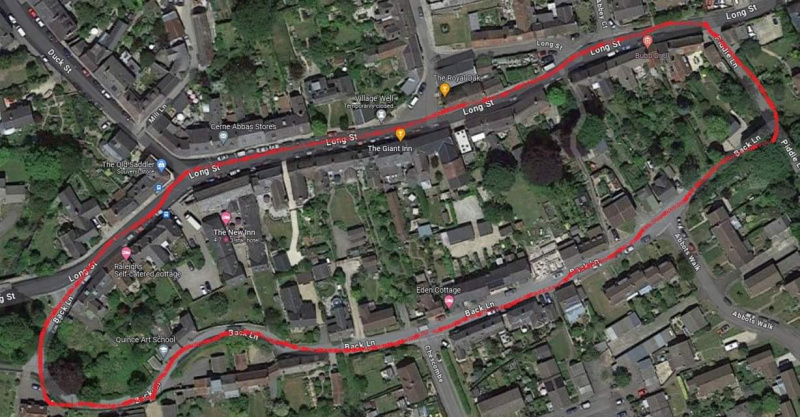
The outlines are showing us the original footprint of the medieval villages. And probably Saxon in origin.
(Source: What is a Medieval Burgage Plot?)
With this information in mind, we can fairly safely assume that any mention of “Back Road/Street” in the following documents actually refers to what we now know as Lincoln Road, between the junction with Torgate Lane in the south end of the village to that with Linga Lane at the north.
1841 – 6th June (District 1): “All that part of the village, lying South of the road leading from the Hallwath to the Street, and East of the Street to Graves Lane, South of that Lane to Lincoln Road, east of Lincoln Road to Linga Lane, and all the houses in the fields South of Linga Lane.” (9 pages; enumerator = unidentified). Named streets and properties are The Rectory, Glebe House (where is/was this? I have no idea), The Bugle Horn, Brickyard, and Old Workhouse.
1841 – 6th June (District 2): “All that part of the village north of the Road leading from the Hallwath to the Street, and west of the Street to Graves Lane, North of that Lane to Lincoln Road, west of Lincoln Road to Linga Lane and all the houses in the fields north of Linga Lane.” (10 pages; enumerator = unidentified). Named streets and properties are Water Lane, Five Bells, and Fen Lane.
1851 – 30th March (2a): “All that part of the Parish of Bassingham lying to the East side of the road leading direct through the village of Bassingham from the end to the other.” (29 pages; enumerator = unidentified). Named streets and properties are Back Street, New Street, Turner? Row, Five Bells, Rectory, Bugle Horn, Navenby Road, Brick Yard, Broughton Road, Wirelock Nook, Standacre Lane, Old Brick Yard, Fen Lane, and Bassingham House.
1851 – 30th March (2b): “All that part of the Parish of Bassingham lying in the North West side of the road leading direct through the village of Bassingham from one end to the other.” (19 pages; enumerator = unidentified). Named streets and properties are Principle [sic] Street (High Street), Hall Wath, Water Lane, and Hall Close.
1861 – 7th April: “The whole of the Parish of Bassingham including Bassingham Low Field.” (40 pages; enumerator: John Pacy). Named streets and properties are Navenby Road, Ley Lane, Broughton Road, Chapel Nook Lane, Wirelock Nooking, Linga Lane, Fen Lane, Lincoln Road, Thurlby Road, Back Street, Bakers Lane, Main Street, Rectory, Allwath [sic], Water Lane, Hall Close, Greaves Lane, and Chapel Street. There are also a few of households listed simply as “Field” and “In the Field”.
1871 – 2nd April: “The Village Parish of Bassingham and Bassingham Low Fields” (39 pages; enumerator = William Rogers). Oddly, there are no named streets and only a very few properties – Bugle Horn, Rectory, Druggist Shop, Wesleyan & Day School, Beer House (x2), Licensed Lodging House, and Five Bells Inn.
1881 – 3rd April: “The whole of the Civil Parish of Bassingham including the Village of Bassingham & the Low Fields ” (31 pages; enumerator = William Frederick Garratt Wilson). Bizarrely, Wilson has dated the front page March 14th 1881, almost one month ahead of the date of the actual census. Once again, there are few named streets, exceptions being Hall Close, Watkin’s Yard, Blackaman? Yard, Reform Yard, Ley Lane, The Brickyard, and Fen Lane. Identified properties are The Vicarage, National School House, Post Office, Wesleyan School House, Grocer’s Shop, Black Swan, Five Bells, The Bugle Horn, The Workhouse, The Wigwam (what?!!), Brant Bridge House, The Wirelocks, Witham House, and Red Bridge House. Of special interest in this census are five characters “roaming about the Parish all night”, presumably of no fixed abode!
1891 – 5th April: “The whole of the Civil Parish of Bassingham including the Village & the low Fields in the Parliamentary Division of Sleaford.” (24 pages; enumerator = John Hammond, 24 pages). Named streets and properties are Hall Field, Water Lane, Black Swan, Main Road, Mission Hall, Bridge Houses, Witham Houses, Lincoln Road, Fen Lane, Low Field, The Brickyard, New Buildings, Navenby Road, Old Workhouse, Back Street, Bakers Lane, Rectory Lane, Village, Bugle Horn, “in the Field”, Cross Street, Five Bells, Chapel & Wesleyan Day School, Chapel Yard, Druggist Shop, Hall Wath, The Rectory, The Church, and National School & Master’s House.
1901 – 31st March: “The whole of the Civil Parish of Bassingham, including the Village & low Fields.” (23 pages; enumerator = John Thomas Poucher). Named streets and properties are Village Street, Bridge Houses, Witham House, Lincoln Road, Narrow Moor Lane, Fen Lane, Brickyard Lane, Stoneacre Lane, Low Field, Wirelocks, Brant Houses, The Cottage, Brick Kiln Lane, Pond House, The Hollies, Carlton Road, School Lane, School Yard, East Gate, Back Street, Water Lane, Moores Yard, Hall Warth [sic], The Rectory, School House, and Hall Field.
1911 – 2nd April: “Bassingham (Entire)” (323 pages; enumerator = John Thomas Poucher). Named streets and properties are North Field, Lincoln Road, Fen Lane, Lowfield House, The Grange, Standacre Farm, Wirelocks, Low Fields, Brickyard, The Building (!), The Cottage (!), The Workhouse, The Hollies, Carlton Road, Bugle Horn Inn, The Hollies (East Gate, I think), East Gate, The Field (!), South View, Witham House (I think there might have been more than one of these), Bridge House, Water Lane, Hall Field, Wath House, The Rectory, The Stores (this is the old Co-Op shop, not Green’s), and Five Bells.
1921 – 19th June: I have no access to this census, but I have provided a link for those who wish to do their own research. I can, however, confirm that named streets and properties are Marenby Horseshoes, Wirelock, Standacre Farm, Bugle Horn, Brickyard Farm, Black Swan, Fen Lane, Witham House and Workhouse.
1931 – This census for England and Wales was destroyed by fire during the Second World War.
1939 Register – 29th September: “North Kesteven Rural District; 417/A1; T.J.C. 1” (15 pages; enumerator = John Thomas Poucher). Named streets and properties are North Field House, North Field, Witham House, Witham Cottage(s), Lincoln Road, Fen Lane, Grange Cottage, Grange Farm, Standacre Farm, Standacre Lane, Wirelocks, Low Fields, Bush Farm, Torgate Farm, Brickyard Cottage, Wirelock Cottage, Navenby Lane, Back Street, East Gate, Bugle Horn Inn, Carlton Road, Rectory, The Mill, Newark Road, The Manor, School House, High Street, Hall Wath, Chapel Jetty, Water Lane, and Croft Lane. *This document, whilst not a census, provides a snapshot of the civilian population of England and Wales just after the outbreak of the Second World War and provides the most complete survey of the population of England and Wales between 1921 and 1951. However, it needs to be noted that many records are redacted, i.e. they are ‘blacked-out’ to protect the identities of people still alive today, which makes it rather difficult to search.
1941 – no census was taken during this year because of the War.
 BACK HOME